Heat, Drought & Fire Weather
📋 Tactical Threat Analysis
Heat and drought scenarios function as slow-moving "creeping disasters." Unlike sudden, violent kinetic events such as tornadoes or flash floods, thermal anomalies systematically suffocate regional agricultural production, critically drain municipal or deep-well water reserves, and place profound physical stress on the domestic electrical grid—frequently pushing infrastructure to the point of rolling brownouts or sudden supply collapses due to extreme air conditioning loads.
🌡️ National Weather Service Live HeatRisk Map
INTERACTIVE DASHBOARDReal-time apparent temperature parameters modeling current boundary-layer relative humidity against ambient thermal values. Use map tools to pan, zoom, or pinpoint regional operating sectors.
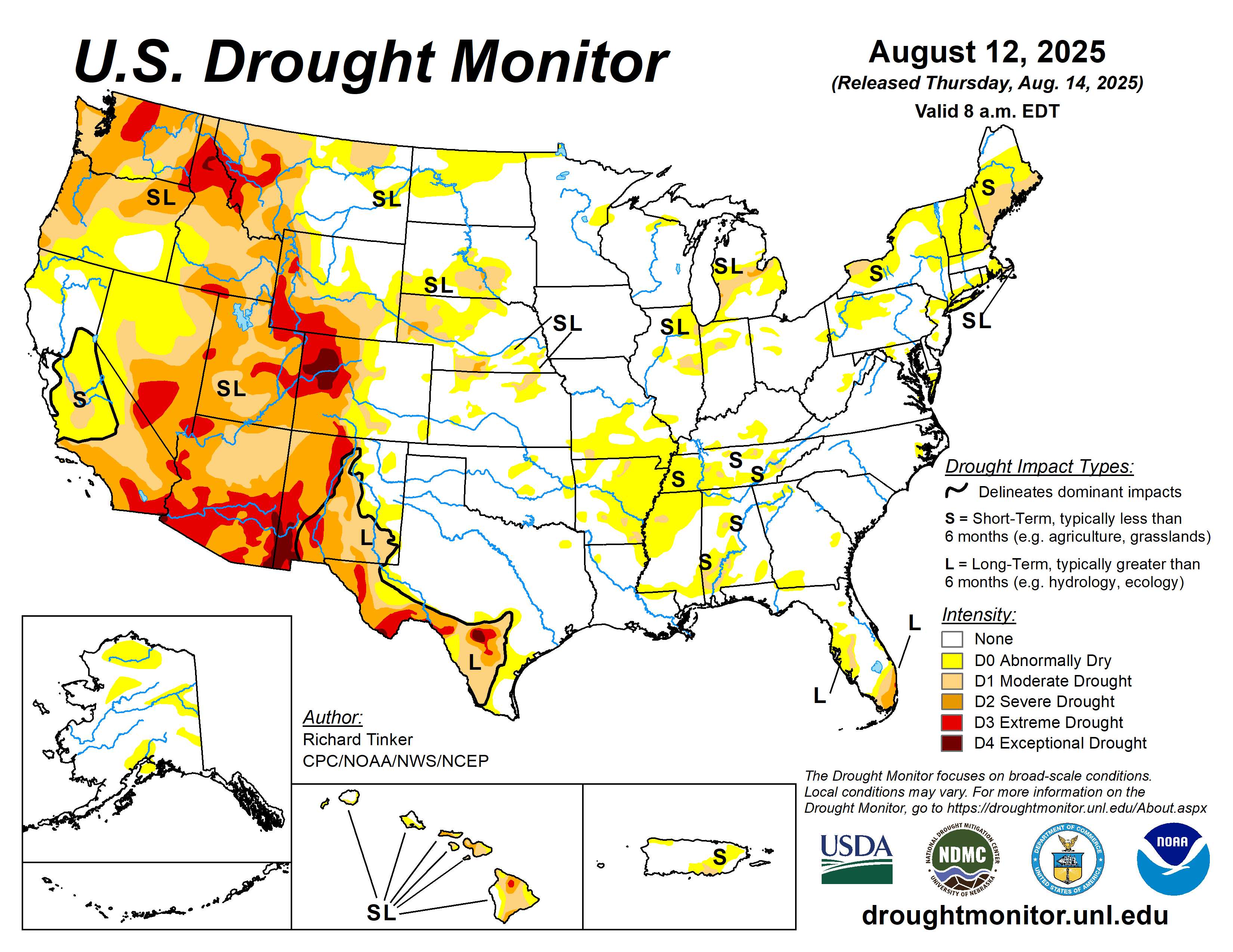
🏜️ US Drought Monitor (USDM) Assessment
UPDATES THURSDAYSProlonged hydrological deficits directly threaten agricultural yields, livestock sustainment, and municipal water tables. Areas in D3 (Extreme) and D4 (Exceptional) drought face critical baseline resource exhaustion.
🌡️ Thermal Hazards (Regional Active Warnings)
Sync Status: 23:26 EDTHeat Advisory issued July 27 at 9:18PM CDT until July 28 at 9:00PM CDT by NWS Mobile AL
Heat AdvisoryAffected Zones: Choctaw; Washington; Clarke; Wilcox; Monroe; Conecuh; Butler; Crenshaw; Escambia; Covington; Mobile Inland; Baldwin Inland; Wayne; Perry; Greene; Stone; George
Expires: Jul 28 — 14:00 EDT
Heat Advisory issued July 27 at 9:18PM CDT until July 28 at 9:00PM CDT by NWS Mobile AL
Heat AdvisoryAffected Zones: Mobile Central; Baldwin Central; Escambia Inland; Santa Rosa Inland; Okaloosa Inland
Expires: Jul 28 — 14:00 EDT
Heat Advisory issued July 27 at 8:36PM CDT until July 28 at 9:00PM CDT by NWS Jackson MS
Heat AdvisoryAffected Zones: Ashley; Chicot; Morehouse; West Carroll; East Carroll; Richland; Madison; Franklin; Catahoula; Tensas; Concordia; Montgomery; Webster; Clay; Lowndes; Choctaw; Oktibbeha; Attala; Winston; Noxubee; Leake; Neshoba; Kemper; Scott; Newton; Lauderdale; Smith; Jasper; Clarke; Adams; Franklin; Lincoln; Lawrence; Jefferson Davis; Covington; Jones; Marion; Lamar; Forrest
Expires: Jul 28 — 11:00 EDT
Heat Advisory issued July 27 at 6:28PM CDT until July 28 at 8:00PM CDT by NWS New Orleans LA
Heat AdvisoryAffected Zones: Pointe Coupee; West Feliciana; East Feliciana; St. Helena; Washington; Iberville; West Baton Rouge; East Baton Rouge; Assumption; Northern Tangipahoa; Lower Plaquemines; Coastal Jefferson; Upper Lafourche; Lower Lafourche; Upper Terrebonne; Lower Terrebonne; Wilkinson; Amite; Pike; Walthall; Pearl River; Northern Hancock; Northern Harrison; Northern Jackson
Expires: Jul 28 — 09:30 EDT
Heat Advisory issued July 27 at 4:33PM EDT until July 28 at 8:00PM EDT by NWS Tallahassee FL
Heat AdvisoryAffected Zones: Geneva; Houston; Madison; Inland Taylor; Lafayette; Inland Dixie; Coastal Taylor; Coastal Dixie; Cook; Berrien; Seminole; Decatur; Grady; Thomas; Brooks; Lowndes; Lanier
Expires: Jul 28 — 20:00 EDT
Heat Advisory issued July 27 at 4:33PM EDT until July 28 at 8:00PM EDT by NWS Tallahassee FL
Heat AdvisoryAffected Zones: Coffee; Dale; Henry; Quitman; Clay; Randolph; Calhoun; Terrell; Dougherty; Lee; Worth; Turner; Tift; Ben Hill; Irwin; Early; Miller; Baker; Mitchell; Colquitt
Expires: Jul 28 — 20:00 EDT
🔥 Combustion Hazards (Red Flag Warnings)
[ Baseline Humidity: No Red Flag Conditions ]
📊 Professional Telemetry Reference Index
Cross-verify field instrumentation and local weather station data strings against these standardized disaster parameters.
| Apparent Temp | Risk & Biological Threat |
|---|---|
| 80°F–90°F | Caution. Fatigue possible during prolonged activity. |
| 91°F–103°F | Extreme Caution. Heat cramps and exhaustion likely. |
| 104°F–124°F | Danger. Heat exhaustion imminent; risk of sunstroke. |
| ≥ 125°F | Extreme Danger. Direct heatstroke threat is critical. |
| Scale | Operational Threat Multiplier |
|---|---|
| 0–200 | Low. Soil saturated; typical post-rain. |
| 400–600 | Moderate. Deep litter dries. Fires resist suppression. |
| 600–800 | Extreme. Ground duff burns hot. Severe spotting risk. |
| Threshold | Field Work Directives |
|---|---|
| ≥ 80°F | Mandatory: 30m rest / 30m labor matrix. |
| ≥ 90°F | Cease non-essential outdoor tactical labor. |
🌱 Agrarian & Infrastructure Critical Thresholds
🛡️ CRP Thermal Protocols
Grid Load Blackouts
Extreme heat domes frequently cause localized transformer failure and rolling brownouts. Ensure primary generators are shaded and cooled to prevent thermal engine seizing during extended runs.
Agricultural & Livestock Hardening
Enforce strict hydration matrices for high-risk livestock. Implement shade structures and assess deep-well pump integrity against rapidly dropping water tables.
Perimeter Fire Breaking
Tractor and mechanical clearing protocols for establishing 50-foot defensible dirt barriers around structural assets and fuel depots.